
La Grana Loop
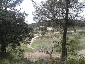
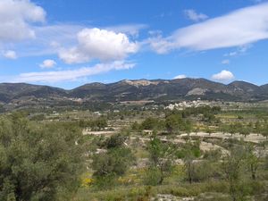
Some nice views over the valley from the quiet road, and also over the hills from the higher loop track.
Spanish maps included within these descriptions are provided courtesy of the Spanish IGN and remain © Instituto Geográfico Nacional.
OSM (OpenStreetMap) and OCM (OpenCycleMap) maps are © OpenStreetMap Contributors. The OSM project welcomes contributions from all to enrich the map data, which is made freely available. Land (Thunderforest Landscape) maps are © Thunderforest based on data © OpenStreetMap contributors.
The grade of this walk is MS/B, which means
MS – Moderately Strenuous: Up to 600 metres ascent and/or no more than 15 km in length with some rough going taken at a reasonable pace.
B – Less than half the route on rough ground
| Nearest town | La Torre de les Maçanes |
| Directions to start |
You start on the quiet road going south from La Torre de les Maçanes. From the CV-782 south of La Torre it’s signposted to Ecopark. |
| Start point (Lat/Long) | 38.598676, -0.417710 Click here to view in Google Maps (in a new browser tab) |
| Length (km) | 13.50 |
| Ascent (metres) | 500 |
| Walking time (hours) | 3.67 |
| Total time (hours) | 4.00 |
| Recommendations or Restrictions | None |
Download walk descriptionDownload GPS file
Comments
La Grana Loop — No Comments
HTML tags allowed in your comment: <a href="" title=""> <abbr title=""> <acronym title=""> <b> <blockquote cite=""> <cite> <code> <del datetime=""> <em> <i> <q cite=""> <s> <strike> <strong>