
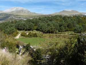
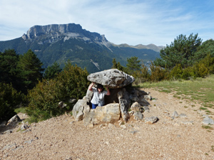
Tella circuit
An interesting loop taking in a set of Ermitas, a Dolmen and wide views.
Spanish maps included within these descriptions are provided courtesy of the Spanish IGN and remain © Instituto Geográfico Nacional.
OSM (OpenStreetMap) and OCM (OpenCycleMap) maps are © OpenStreetMap Contributors. The OSM project welcomes contributions from all to enrich the map data, which is made freely available. Land (Thunderforest Landscape) maps are © Thunderforest based on data © OpenStreetMap contributors.
The grade of this walk is S/A, which means
S – Strenuous: More than 600 metres ascent and/or more than 15km in length with steep, loose or heavily vegetated sections.
A – All good tracks.
| Nearest town | Bielsa |
| Directions to start |
From northern Spain, E of both Jaca and Sabinanigo on the N260 take the A138 north to reach the small hamlet of Hospital de Tella and here take a minor road directly towards Tella. A little way along here you reach a winding set of tight zig-zags at Cortalavina. When you reach a track junction -signed Mirabal – on the L park just past this on the RHS or on the start of the track. |
| Start point (Lat/Long) | 42.563619, 0.172558 Click here to view in Google Maps (in a new browser tab) |
| Length (km) | 12.00 |
| Ascent (metres) | 610 |
| Walking time (hours) | 3.75 |
| Total time (hours) | 4.75 |
| Recommendations or Restrictions | None |
Download walk descriptionDownload GPS file
Comments
Tella circuit — No Comments
HTML tags allowed in your comment: <a href="" title=""> <abbr title=""> <acronym title=""> <b> <blockquote cite=""> <cite> <code> <del datetime=""> <em> <i> <q cite=""> <s> <strike> <strong>